Three powerful Pacific hurricanes churning at the same time make weather history
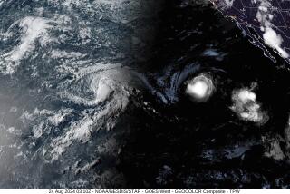
For a time over the weekend, three powerful Category 4 hurricanes churned in the central and eastern Pacific basins at the same time, an event that is believed a meteorological first in the ocean region and another sign that the forces of El Niño are stirring up weather anomalies — and the jitters in Hawaii.
Hawaii on Monday appeared to have dodged a swipe from Hurricane Ignacio, which had substantially weakened to a Category 2 on a five-point scale as it moved hundreds of miles off-shore of the state. But that sense of relief was tempered by the knowledge that the islands are just halfway through the hurricane season and already have seen almost as many named storms as the Pacific region usually gets in an entire period.
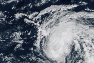
Over the weekend, officials recorded three named hurricanes — Ignacio, Kilo and Jimena — and all were as strong as Category 4. Kilo and Jimena are not expected to directly hit the Hawaiian islands. National Weather Service meteorologist Chevy Chevalier said it was possible that Ignacio could stage a dramatic shift toward land, “but not likely.”
Even though the storms are forecast to miss Hawaii, officials have had to gear up emergency measures as a precaution. Stores have reported an increase in purchases of emergency supplies, declarations of warning have been issued by state leaders and emergency management officials and hundreds of volunteers have been put at the ready by groups such as the Red Cross.
“This hurricane season seems to be busier than normal,” said Krislyn Yano, communications manager for the state chapter of the Red Cross. “We don’t want residents to get fatigued by the close calls then think we’re invincible” when the storms pass. “We are always trying to be prepared, and we’re only half way through the season. Everyone should always be ready.”
According to Chevalier, a meteorologist for the Honolulu-based Central Pacific Hurricane Center, part of the National Oceanic and Atmospheric Administration, the region averaged 16.6 named storms a year from 1981 to 2010. The largest number, 28, was recorded in 1992 and the fewest, eight, was in 1977 and 2010.
So far, there have been 14 named storms in the region, and the hurricane season, which runs from mid-May to the end of November, is only about half over, he said. The forecast had been for 15 to 22 storms this year, he said.
“This year, we have had a very active hurricane season and the main reason is El Niño,” he explained. The El Niño effect occurs when sea water has a warmer than average temperature.
In general, hurricanes are born in the eastern portion of the Pacific where warm waters generate water vapor and energy that climbs into the air. The heat of the water is like a fuel that feeds the hurricane, making it stronger and fiercer and as it travels over the water.
Normally, the cool ocean water serves as a brake to the growth of hurricanes. But in an El Niño year, the ocean stays warm and continues to feed the baby hurricanes that then can grow into fearsome creatures. The tamest hurricane, as measured on the five-step Saffir-Simpson Hurricane Wind Scale, starts at 74 miles per hour, the low end of Category 1. The high end of Category 5 is more than 157 miles per hour. The top steps are considered major storms with winds in excess of 112 miles an hour.
“When the hurricanes reach the Hawaiian Islands, the sea surface temperatures are normally relatively cooler, so the storms lose some power. This year is different [because of El Niño] and the hurricanes have maintained their intensity as they move north.”
By Monday, Kilo remained a Category 4 storm, approaching the International Date Line with winds of 135 miles per hour. Jimena, with winds of 150 miles an hour, was more than 1,300 miles east of Hawaii.
Ignacio weakened, with maximum winds of 105 miles per hour. It was forecast to continue to lose power through the week as it moved hundreds of miles past the Big Island and Maui. No coastal warnings or watches were in effect, according to the National Weather Service.
Many storms brush the islands or cause enough disturbance in the ocean to have an effect, Chevalier said. Only four storms have made landfall in Hawaii since 1949; two caused major damage but none since 1992.
Still, for a time all three were Category 4 storms in the same region. Even three Category 3 storms would be a record, Chevalier said.
“I would say it’s very rare, extremely rare,” he said. “I don’t think it has ever happened before.”
Follow @latmuskal for national news
More to Read
Sign up for Essential California
The most important California stories and recommendations in your inbox every morning.
You may occasionally receive promotional content from the Los Angeles Times.
