Photographer captured iconic lightning photos — and risked getting zapped himself
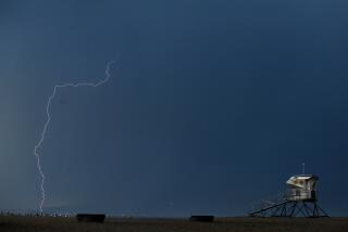
Mike Eliason stood in a puddle at the end of a wooden wharf over the ocean in Santa Barbara as a dramatic lightning storm off the Southern California coast lighted up the sky. Thunder roared like someone was shaking sheet metal. He set up his metal tripod and camera.
“What could possibly go wrong?” the Santa Barbara County Fire Department spokesman joked Wednesday afternoon. “All I really needed ... was a golf club in my hand and I’d be perfectly set.”
His risky undertaking the night before — which admittedly broke many of the rules for avoiding being struck by lightning, but from which he emerged unscathed — produced some of the most spectacular long-exposure images of the lightning show that defined the latest storm of this year’s wild winter in California.
In one five-minute stretch alone, the National Weather Service recorded 1,489 pulses of lightning off the coast, 231 over Santa Barbara County and 40 in Los Angeles County, said Kathy Hoxsie, a meteorologist with the weather service in Oxnard.
“It was quite an impressive show — by Santa Barbara standards, for sure,” Eliason said. “I’m sure people in Texas and Oklahoma are just rolling their eyes at us.”
At one point, a lightning strike knocked the power out at Stearns Wharf and Santa Barbara’s waterfront for about 10 seconds. It wasn’t until nearly two hours into Eliason’s shoot that he decided he’d had enough: Lightning was flashing in every direction like massive spiderwebs in the sky.
“This is time,” he recalled thinking. “I should pack it up and call it a night.”
The storm drenched Santa Barbara County overnight, hammering the region with heavy rain, hail and thunderstorms, and moved into Los Angeles County early Wednesday.
Bands of heavy showers in Malibu sent mud and rocks sliding onto Malibu Canyon Road, temporarily blocking a portion of the southbound side, as the storm settled into L.A. early in the day. By evening, the storm had broken daily rainfall records in several areas, including downtown L.A., Los Angeles International Airport and Lancaster.
Downtown Los Angeles received at least 1.24 inches Wednesday, breaking the record for the date of 0.88 inches in 1884.
Much of Southern California has received above-average rainfall for this time of the year, and many areas have already recorded an average year’s worth of rain. Downtown L.A. has received 17.98 inches since the water year began in October, surpassing the 14.93 inches the city gets on average annually.
That’s a sharp turnaround from the last water year, which was the third driest since records began in 1877, with a meager 4.72 inches of rain. Prior to this water year, six of the past seven water years — which run from Oct. 1 to Sept. 30 — have been below average.
The Sierra Nevada, California’s greatest mountain range, has also been seeing a banner year for precipitation. All three regions of the Sierra are almost at the point where they will have seen a year’s worth of precipitation for the season.
Forecasters predict scattered showers through Friday.
Up to 2 inches of rain was expected to fall in Malibu, Woodland Hills, Santa Clarita and Pasadena through early Thursday, while the rest of Greater Los Angeles will probably see an inch or slightly more, according to the weather service.
Public health officials advised people to avoid swimming and surfing at beaches through Saturday morning, saying bacteria and debris can wash into the ocean from city streets when it rains.
The brunt of the storm hung over Santa Barbara and Ventura counties overnight Tuesday, dumping nearly a quarter of an inch — 0.24 — on the Thomas fire burn zone in just nine minutes. As of early Wednesday, the atmospheric river, swollen with subtropical moisture, had poured 2.61 inches of rain on Potrero Lane in Santa Barbara County and more than 3 inches on the Pine Mountain Inn in Ventura County within 24 hours, according to the weather service.
Forecasters said it wasn’t typical for an atmospheric river, which carries warmer air, to produce hail. The frozen rain pellets were probably the result of a cold front pushing the storm through the region, which caused some instability in the atmosphere, likely contributing to the lightning display.
Lightning strikes briefly knocked out power at three Los Angeles International Airport terminals and the Santa Barbara airport. Other strikes sparked small fires and set palm trees ablaze across the region.
A Delta flight to Seattle returned to LAX after being struck by lightning, Los Angeles Airport Police Officer Rob Pedregon said. No injuries were reported.
Concerns over flooding in Santa Barbara County prompted authorities to order evacuations ahead of the storm for about 3,000 people living below hillsides ravaged by the Sherpa, Thomas and Whittier fires. Santa Barbara County sheriff’s officials lifted the evacuations Wednesday morning after the rain failed to trigger significant mudslides in the region.
“We actually fared pretty well, considering what we went through,” Eliason said.
Times staff writer Rong-Gong Lin II contributed to this report.
Twitter: @AleneTchek
More to Read
Sign up for Essential California
The most important California stories and recommendations in your inbox every morning.
You may occasionally receive promotional content from the Los Angeles Times.


