Huge California storm wallops water-starved state; more to come
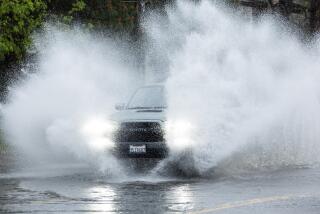
The bigger, badder of two rainstorms that weather forecasters had predicted arrived on schedule late Thursday, drenching a very parched California while causing a slew of hazards along the way.
The system is forecast to hover over California through at least Saturday, dumping several inches in some regions – including Los Angeles – before it leaves. Already, Van Nuys had measured nearly two inches of rain in just six hours Friday, with weather forecasters warning of another wave expected to hit the area in the afternoon.
Bay Area forecasters said the heaviest bands of rain had passed overnight, but local showers could still pose problems for commuters.
Rain and wind knocked out power to thousands of customers north of San Francisco on Friday morning, the San Francisco Chronicle reported. Wind and rain advisories were in effect for the region through Friday night.
City workers in Bakersfield scrambled ahead of the deluge to clear storm drains notorious for clogging during big storms, the Bakersfield Californian reported. And the National Weather Service issued a wind advisory for the Grapevine pass into the Central Valley.
The advisory was one of dozens of winter storm, wind, high surf, flood and rain warnings forecasters issued for counties across the state.
Experts said the storm looks to be the biggest downpour to hit Los Angeles in at least two years, though it isn’t expected to make much of a dent in California’s historic drought. But Bob Benjamin with the National Weather Service said it was “a step in the right direction.”
“Even though we’re getting some consequential rains… we’re still a long ways away from getting toward normalcy,” he said. “This will certainly keep us from going backward, but I don’t think it’ll bring us up to where we should be.”
The storm is especially concerning for residents in the foothills of Azusa and Glendora, where thousands of residents live in the path of potential mudslides. The southern face of the San Gabriel Mountains were left vulnerable after the Colby fire burned away its vegetation and baked the soil, keeping precious moisture from soaking into the earth.
Already, soupy mud was seen flowing into the yards of homes up against the burn area Friday morning as officials braced for heavier rain. More than four feet of mud had filled the Harrow Debris Basin in the San Gabriel hills by about 9 a.m., according to the Los Angeles County Department of Public Works.
Anticipating heavy runoff, officials erected concrete K-rail barriers to direct the flow of any mud and debris coming down from the Colby fire burn area.
Up to 1,000 homes in the section affected by the burn area in Azusa and Glendora are under a mandatory evacuation order amid fears that mud and debris could inundate their homes. The Glendora Police Department urged residents to leave, warning that they faced “injury and/or death.”
Glendora residents north of Sierra Madre Avenue between Yucca Ridge Road and Glendora Mountain Road must evacuate. In Azusa, the order applies to residents on Ridge View Drive. Both areas are situated below the burn area, which denuded hillsides of rock- and dirt-holding vegetation.
Larry Davis, 69, lives in the mandatory evacuation zone in Glendora, but said he stayed behind after police said a high wall on his property would probably protect his home.
He said he had wanted to drive his son to school but decided he couldn’t drive over the mud and debris that had accumulated at the intersection at Hicrest Road and Sierra Madre Avenue.
Standing on his driveway, he watched as muddy water and branches made their way down the street.
“This is the most rubbish I’ve ever seen,” Davis said.
Dennis Madvig, 66, also said he decided not to evacuate from his Glendora home even though there appeared to be a mudslide threat nearby.
Early Friday morning, he walked along Hicrest Road after mud and debris from the hills had rolled down. He said the road was built as a flood control channel after a major flood in the area more than four decades ago.
“This is nothing yet,” he said.
Twitter: @josephserna
More to Read
Sign up for Essential California
The most important California stories and recommendations in your inbox every morning.
You may occasionally receive promotional content from the Los Angeles Times.


