Why this week’s Santa Ana winds may be the strongest of the season so far

After a brief pause on Tuesday morning, strong, cold offshore winds are expected to return to California through Thursday.
“Wednesday’s and Thursday’s wind events have the potential of being the strongest of the season,” said Bill Patzert, a retired climatologist from the Jet Propulsion Laboratory in La Cañada Flintridge. “The worst of the punishing winds may be yet to come.”
The winds that tend to be the most intense are the cold Diablo and Santa Ana winds, Patzert said. That’s because cold air is heavy and it gains momentum as it plummets downslope from higher elevations toward lower pressure at sea level.
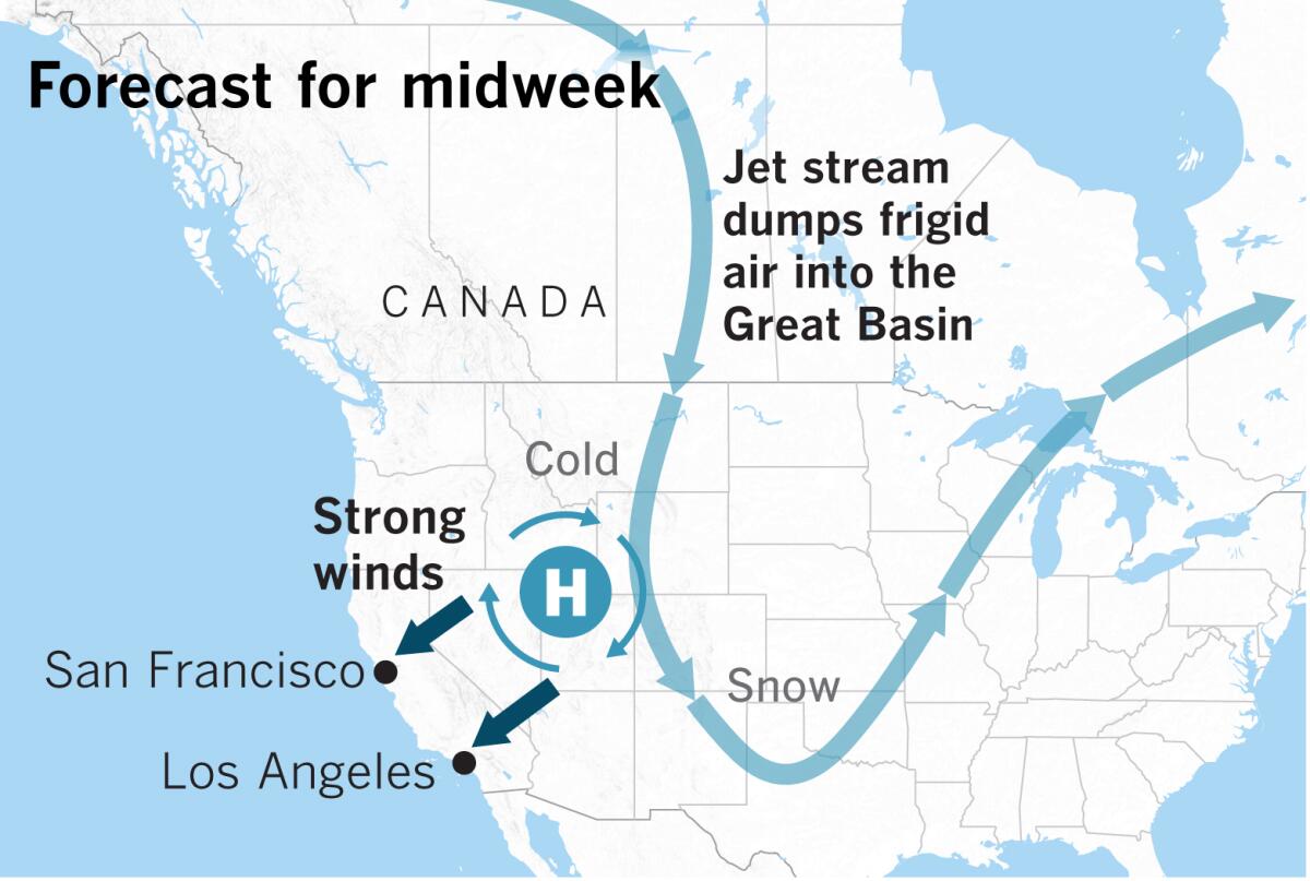
Frigid, dry arctic air from Canada is being deposited by the jet stream in a large area of high pressure in the Great Basin. This process is called advection, which means the transport of an atmospheric property by the wind.
The clockwise circulation around that high-pressure system generates winds that are being driven over mountain peaks and through narrow passes and canyons, which increases the velocity and dries the air out more. And the air is colder and heavier because it originated up near the Arctic Circle, so it gains more momentum than in a warmer, offshore wind event.
This pattern is true of both Diablo and Santa Ana winds. It’s largely the same story but with different geography. The Diablo winds lift over the Sierra Nevada, cross the Central Valley , then surmount the Coast Range. In Southern California, Santa Ana winds descend from inland deserts, climb over the Transverse Ranges or blast through passes such as the San Gorgonio, a portal opening directly on the Great Basin.
The same jet stream, if it shifted about 500 miles to the west, would bring California winter rainstorms from the Gulf of Alaska. “We would be talking about the beginning of the winter rainy season. This is a typical winter pattern,” said Patzert, “but what we’re seeing is a dry winter pattern, a classic October-November-December Santa Ana.” About a week ago there was a mention of a chance of rain in the forecast for this week, “but the jet stream didn’t cooperate.”
“After a punishing October, let’s keep our fingers crossed for a wet November,” Patzert said.
The jet stream is expected to shift and the winds should relax late this week.
The forecast prompted Southern California Edison to say it could shut off power to more than 350,000 customers.
More to Read
Sign up for Essential California
The most important California stories and recommendations in your inbox every morning.
You may occasionally receive promotional content from the Los Angeles Times.


