With Google’s Photo Sphere, users contribute photos of remote spots
Mounted on cars, bikes and even snowmobiles, Google Street View cameras have been scouring the globe taking panoramic pictures of roads, alleys and buildings.
The images have redefined the way people navigate, turning two-dimensional maps into a virtual tour guide.
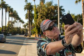
But Google is seeing even more possibilities for one of the most popular Web tools. The search giant wants to turn your smartphone into a Street View camera and help it take 360-degree, interactive pictures of every nook and cranny on Earth.
Eventually, Google wants its users to be able to view not only landmarks and buildings but also remote hiking trails, insides of theme park attractions and beach hideaways — wherever a smartphone can go.
“We want to go everywhere. The idea with this project is to show you the world as it is, to bring you good imagery anywhere you might be interested in looking,” said Luc Vincent, Google Maps engineering director. “At a city level, at a street level, indoor, outdoor, on a trail, in Antarctica, in Africa, in the U.S. — everywhere.”
But although many travelers are lauding the Photo Sphere initiative, it is raising concerns among privacy advocates and watchdog groups.
Parker Higgins, a spokesman for the Electronic Frontier Foundation, said that although Google is not breaking any laws, some people already were bothered by Street View simply because they weren’t used to the fact that anyone can type in their street address and see their house.
“In other parts of the world, people are very uncomfortable with the idea of Google coming through and photographing everything, and you can imagine that they’d be even more uncomfortable with individuals doing this and collectively uploading to Google,” he said.
Google has taken steps to placate privacy worries with Street View, such as automatically blurring faces and license plates captured in photos by Street View vehicles.
It has no plans to do so for the Photo Sphere images but said it has put in place a team of moderators to weed out racially derogatory or sexually explicit images. Users can also easily file a report of a photo that may include privacy violations. It’d be up to Google to delete the image.
“Because the photos go through the moderation process before they are even published, I don’t think we have concerns about things slipping through the cracks, and if they do, of course we have the tools that users can use to report issues,” said Sierra Lovelace, a spokeswoman for Google.
Owners of certain smartphones were able to take Photo Sphere photos starting last November, but Google ramped up the initiative this summer with a new “Views” website where the images can be seen.
To populate the website with images, Google has begun recruiting individuals to contribute, the same way content was built up for online encyclopedia service Wikipedia.
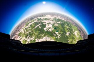
For now, only those with a smartphone running Google’s Jelly Bean 4.2 or higher operating software with the Google camera app can take the pictures, which involves the smartphone user standing in a spot and turning in a full circle while holding the camera.
The user can then view the 360-degree image on the camera before uploading to Google Maps to be shared publicly.
Google did not disclose how many Photo Sphere images have been submitted or published, but so far there are photos submitted from as far away as North Slope, Alaska, down to the South Pole.
The photos can be seen on Google Maps when users search for a place and select the “photos” option. They can also be viewed on Google’s “Views” website.
Photo Sphere contributors are making it possible for Google to provide helpful imagery in places Street View has not yet reached. Photo Sphere images can help users get a sense of place.
“Everywhere we go, people are just wanting more and more coverage,” said Evan Rapoport, the product manager for Photo Spheres. “So we started really looking at how do we take the technology that we developed in Street View to create these panoramas from individual images and make it available to everyone.”
For instance, Google’s Street View vehicles have yet to reach Maldives, but there are many Photo Sphere images of the small island nation, which is in the middle of the Indian Ocean. That’s because visitors and residents there have begun to use the Google feature.
One user, a surveyor who travels around the country regularly, has been uploading Photo Spheres since the feature first became available in November, and since then, he has posted 70 publicly viewable Photo Spheres.
Munah Ahmed, 28, says Photo Sphere allows him to capture a 360-degree image of the places he visits and see them just as they were when he was there.
Ahmed said that with Photo Sphere, Maldives is showcased with a local’s perspective, not just what you might see in a travel brochure.
“If they want to cover the whole world, they need to let their users help them,” Ahmed said. “‘Cause even for Google, who knows everything, covering local-related things, they need locals.”
Twitter: @sal19
More to Read
Inside the business of entertainment
The Wide Shot brings you news, analysis and insights on everything from streaming wars to production — and what it all means for the future.
You may occasionally receive promotional content from the Los Angeles Times.


