Storm Trackers Improving Forecasts
OVER THE PACIFIC OCEAN — Behind the cockpit of the Gulfstream jet, flight meteorologist Stan Czyzyk counts the seconds until the next launch of instruments tracking a storm that is poised to threaten the Winter Olympics in Salt Lake City.
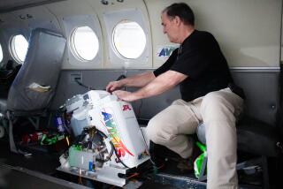
At 41,000 feet above the Pacific Ocean, two engineers at the rear of the specially modified plane wait for him to utter one word into their earphones.
“Drop.”
At that command, Richard McNamara places a cylinder into a chute and Dan Lino pushes a button, opening a small trapdoor. The 1-pound cylinder shoots out with the sucking sound of a vacuum tube at a drive-up bank window. The airborne container sprouts a tiny parachute for its 20-minute descent to the Pacific before sinking 14,000 feet to the bottom of the ocean.
During the seven-hour flight from Anchorage the day before the start of the Olympics, the crew launched 26 of the pressboard cylinders to collect data on the developing cold front. The mission was part of the National Oceanic and Atmospheric Administration’s efforts to survey severe winter storms born in the vast, largely unmonitored north Pacific and improve weather forecasts across the United States.
The crew averages five missions every two weeks.
“We’re measuring the atmosphere surrounding the storm,” said program manager Jack Parrish, dressed in a blue flight suit like the rest of the 10-man crew aboard the Gulfstream G-IV. “Think of a storm as a floating cork in a stream. It can only go where the stream takes it. We’re measuring the stream.”
From such a high altitude, that meant a smooth ride, other than a bout of jet-stream turbulence that briefly rattled the 13-seat plane as it soared high above a frozen cloud. But plenty of chaos lurked in the science involved during the 3,000-mile flight from the Gulf of Alaska to the “middle of nowhere” west of the Northern California coast.
The cylinders, priced at $600 apiece, measure humidity, temperature and the speed and direction of wind at various elevations of their descent.
On a computer, Czyzyk hustled to process the signals arriving twice every second. He constantly flipped between screens of solid numbers and colorful squiggly lines akin to a child’s crude drawing.
The incoming data was transmitted by satellite to NOAA’s National Centers for Environmental Predictions in Suitland, Md. There, supercomputers develop forecast models, incorporating information from various sources, including the Gulfstream jet, a few scattered weather buoys and weather balloon launching sites on Adak, Hawaii, and Wake Island on the other side of the International Dateline.
Much of the atmosphere over the Pacific is not measured, however, other than by the flyovers launched in 1998 through NOAA’s Aircraft Operations Center. The AOC crew works from Alaska and Hawaii with a team from the Air Force Reserve.
The computers in Suitland use physics to move predictions forward in time intervals, creating current weather pictures as well as short- and long-range forecasts.
Reports are distributed to the National Weather Service and picked up by news outlets and organizations that handle emergency services, agriculture, aviation and recreation.
The cylinder drops create more accurate, far-reaching forecasts, giving people extra time to prepare for snowstorms and blizzards, mudslides, severe winds and floods.
“Basically, it means an extra day’s lead time on the weather,” Parrish said. That extra time is crucial to plan evacuations, close schools and warn people to stay indoors. It also helps utility companies share resources during emergencies.
“Very few storms catch you by surprise,” Parrish said. “But they could be 15% to 20% stronger than expected. That information makes a difference.”
The Anchorage leg of NOAA’s two-month mission ended Feb. 16. The crew will trade places with the Air Force Reserve in Honolulu until the program ends March 20.
During warmer months, storm trackers chase hurricanes from Gulfstream and other research aircraft based at the Aircraft Operations Center at MacDill Air Force Base in Tampa, Fla. Those rougher rides yield higher doses of adrenaline--and relative calm.
Parrish, an experienced hand at tracking storms, has flown through the peaceful eye of hurricanes 405 times in his career.
During the recent mission, the NOAA crew followed the northern edge of the Pacific storm while the Air Force Reserve tracked the southern edge. The storm was forming 1,000 miles north of Hawaii and 2,000 miles from the West Coast, traveling east.
Each cylinder drop brought a flurry of calculations for Czyzyk, who barely had time to pop his lunch into the plane’s microwave. But weather is constantly changing, so speed is essential.
In the afternoon, Parrish offered to take over for a while.
“Now is a good time,” Czyzyk said. “There’s nothing to do for the next minute, 15 seconds.”
By late in the day, the forecast showed ideal conditions for the Winter Games.


