Raging Yosemite Fires Slow Their Pace, but More Trouble Looms : Disaster: Tuolumne Grove appears to be out of danger. Thick smoke in the valley and the prospect of new lightning strikes have rangers worried though.
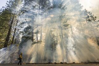
YOSEMITE NATIONAL PARK — Fires slowed their race through Yosemite’s woodlands Monday, but rangers were concerned that new lightning storms may be on the way and about thick, acrid smoke that has settled into Yosemite Valley, which could remain closed to visitors all week.
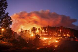
Nearly 18,000 acres of forest have burned so far inside Yosemite in three separate fires, all set by lightning. There was no estimate of containment for the biggest, the so-called A-Rock fire, which had scorched 13,393 acres--6,248 of them inside the park--and may also have left conditions potentially dangerous to health.
Fire officials called in a hazardous materials team Monday to investigate possible cancer-causing chemicals and materials in the burned-out community of Foresta, inside the park.
Firefighters discovered downed power lines and old transformers containing PCBs, which had fallen and ruptured on the ground. They also found asbestos and unidentified melted metals, officials said.
“One lightning storm, two lightning bolts and a wind storm changed this place overnight from peace and serenity to the first evacuation in the (park’s history),” ranger David Balogh said Monday. “Things are going to be burning in this park into the second and third snowfalls in October and November.”
On the positive side, the danger appears to have passed for the Tuolumne Grove of giant Sequoia trees in the northwest area of the park. Also, park officials said full containment could come by Thursday of the so-called Steamboat fire, which has consumed 4,000 acres. A third fire, in the Aspen Canyon area, has burned about 645 acres and is 45% contained.
Yosemite Valley, which was blanketed Monday in a thick fog of smoke and dropping ash that stung eyes and irritated lungs, was not expected to reopen before Thursday at the earliest, park Supt. Michael Finley said.
Although visitors with reservations have been allowed entry to high country campgrounds and the Wawona area, the valley smoke--caused partly by backfires set by firefighters--was so bothersome that Mariposa County health officials and the park service were monitoring the air for a health risk to workers who remain.
Several hundred employees of Yosemite Park & Curry Co. live in the valley--a box canyon surrounded by tall granite cliffs on three sides--and the park service also has its fire command center there.
“If the smoke gets real bad, we’ll move out the Curry Co. employees and we could even move our own operations out of the valley,” ranger Mark Fincher said.
Finley said the valley, which typically is visited by more than 10,000 people on summer weekdays, also cannot be reopened because park rangers and naturalists are needed on fire duties. It is possible the valley may remain closed through next weekend, further snarling the travel plans of those who had felt lucky to obtain reservations at the Ahwahnee Hotel and other valley accommodations.
When the valley is cleared for tourists again, they will likely be readmitted gradually, he said.
“Just like we planned the evacuation in waves, we’ll refill the valley . . . in stages,” Finley said. “The real critical thing here is safety.”
Finley acknowledged that inadequate communication equipment had hindered firefighters, who could not save about 66 buildings destroyed in the Foresta area. The park has only three radio frequencies available for emergencies.
“There have been some logistical flubs,” Finley said Monday. “To the extent that we have enjoyed success, it has not been because we have enjoyed (good) communication.”
Naturalists also are considering whether to issue a warning about overly aggressive squirrels, raccoons and other animals. With the valley all but devoid of people for the first time in many years, some animals are growing testy about their forced withdrawal from the picnic leftovers and junk food handouts visitors give them.
A couple visiting at Glacier Point on Sunday reported being hounded by a pack of about 30 squirrels, and naturalists also have observed unusual activity by the park’s mule deer, blue jays and coyotes.
“Animals may be suffering some stress because they don’t have what they are used to in the way of food,” said Dan Cord, a park naturalist. “It’s a serious irony, but I don’t think they’ll starve to death.”
On Sunday, Yosemite officials convened a task force to study how to return the forest floors to a semblance of their natural state. While the fire damage itself is natural, the 12 miles of fire lines scraped into the terrain by bulldozers are not.
“It’s unique to bulldoze fire lines in a national park,” ranger Balogh said. “If we leave them alone, rainfall can turn them into gullies. We may want to seed them or revegetate them.”
Despite all the attention focused on world-famous Yosemite, the worst California fires for acreage are in Tehama County’s hills on the east side of the Sacramento Valley, northeast of Red Bluff.
One fire alone, west of the community of Cohasset, had burned 114,000 acres and was 70% contained by Monday afternoon. A smaller fire near Manton has scorched 17,500 acres and was half contained with no communities threatened, said Lisa Boyd, spokeswoman for the California Department of Forestry and Fire Protection.
In Sacramento, the department’s director, Harold R. Walt, delivered a somber briefing on the statewide fire situation to Gov. George Deukmejian.
“The outlook is grim,” Walt said. “The existing fires will require weeks to control. Weather conditions and new fires will stress firefighting forces to extreme limits.”
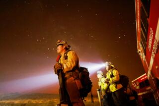
In all, 12,000 firefighters are on the line in California battling 11 major fires that are still burning--out of 1,300 fires touched off by recent lightning, Walt said. More than $40 million has been spent fighting the fires, but even so 210,000 acres have burned.
“We are pleased there have been no major losses in terms of lives or injuries,” Deukmejian said Monday. “On the other hand, the situation is extremely serious.”
Weather forecasters say new lightning storms may be on the way to the Sierra Nevada, and they again may be of the dry variety. In this sort of storm, there is little accompanying rain to quench the fires.
And if new fires erupt, firefighters may be too taxed to react quickly.
“We’re stretched pretty thin now,” Department of Forestry spokesman Bill Teie said. “If we have new fires, we’ll have to start setting priorities.”
Meanwhile, evacuated residents began returning Monday to Yosemite West, an enclave of private homes and summer cabins within Yosemite. The community of about 72 homes survived without damage despite being on a steep slope underneath a dense forest of ponderosa pine trees.
Fire officials say the fire turned away naturally rather than whipping through the community. Residents had fled on Friday expecting the worst.
“We said goodby to it,” said Mike Manahan, a resident since 1980. Before leaving, he grabbed four boxes of his children’s mementos and an Ansel Adams photograph of a Boy Scout group at Yosemite. Manahan is the scoutmaster in the 1947 photo.
“Those are things that you just can’t replace,” Manahan said.
Lee Hotchkin also returned Monday with his cairn terrier, Taffy. “If the only thing we had been able to save was the dog, we would have been happy,” Hotchkin said.
Roderick reported from Los Angeles and Sahagun from Yosemite. Times staff writer Harold Maass also contributed from Yosemite.
MAJOR FIRES IN CALIFORNIA In HUMBOLDT County: 1. Southern Humboldt County, near the King Range National Conservation area. 16,300 acres burned no structures lost 50% contained In SHASTA County: 2. Northeastern Shasta County, 25 miles northeast of Burney, in Burney State Park, which is evacuated. 3,950 acres burned 2 structures (both outbuildings) lost 10% contained 3. Northwestern Shasta County, north of Redding. 7,785 acres burned no structures lost but a Bald Eagle habitat is threatened. 50% contained In LASSEN County: 4. Two fires 50 miles northeast of Susanville, near Ravendale: Near Shinn peaks 16,000 acres no structures lost 85% contained Branham area 8,680 acres no structures lost 100% contained, meaning the fire is still burning but has a cut fireline around it. In TEHAMA County: 5. Eastern Tehama County, west of Cohasset. 114,000 acres burned 17 structures lost 70% contained 6. 25 miles east of Red Bluff 17,500 acres burned 13 structures lost 50% contained In MARIPOSA County: 7. Yosemite Fires (3 fires in all): Near the Arch Rock entrance to the park, north of the Merced River, between California 140 and California 120. 13,393 acres burned 66 structures lost 45% contained South of the Merced River, near California 41. 4,000 acres burned no structures lost 50% contained Aspen Valley area. 645 acres burned no structures lost 45% contained In KERN County: 8. Sequoia National Forest, 2 miles northwest of Kernville. 24,200 acres burned no structures lost 40% contained Source: California Dept. of Forestry and Fire Protection, Sacramento.
More to Read
Sign up for Essential California
The most important California stories and recommendations in your inbox every morning.
You may occasionally receive promotional content from the Los Angeles Times.


